Riyadh Metro Routes
Riyadh Metro Routes
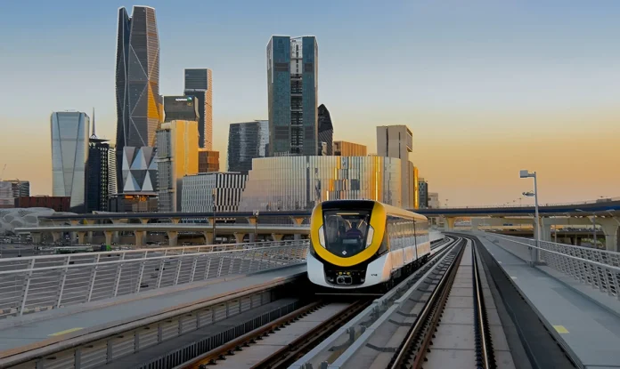
The Riyadh Metro changes how people move in Saudi Arabia’s capital. Launched in 2024, it spans 176 kilometers with six colorful lines and 85 stations. It’s the world’s longest driverless metro, connecting busy Olaya Street to historic Qasr Al-Hokm
Riyadh Metro Overview
The metro supports Vision 2030, making travel faster and greener. It links key spots like King Saud University and King Khalid International Airport. Residents save time, tourists explore easily, and urban planners admire its smart design. Over 1.9 million riders used it in its first week, per the Royal Commission for Riyadh City.
The Riyadh Metro powers the King Abdulaziz Project for Riyadh Public Transport. It covers 176 kilometers with six lines and 85 stations. By January 2025, it fully operates, carrying up to 3.6 million passengers daily. Its driverless trains, a first for Saudi Arabia, ensure safe, fast travel. Solar-powered stations save 20% of energy, making it eco-friendly.
This metro connects Riyadh’s key spots, from schools to business hubs. It works with 80 bus routes to ease travel across the city. The metro supports Vision 2030, cutting traffic and pollution. “Riyadh Metro sets a global standard for sustainable transport,” says the Royal Commission for Riyadh City. It served 1.9 million riders in its first week of 2024.
Exploring the Riyadh Metro Routes
The Riyadh Metro routes connects the city with six colorful lines. Each line serves unique areas, from busy markets to quiet neighborhoods. Below, explore each line’s route, key stations, and features. Plan your trip with the Riyadh Metro routes Guide app or visit rcrc.gov.sa for an official route map.
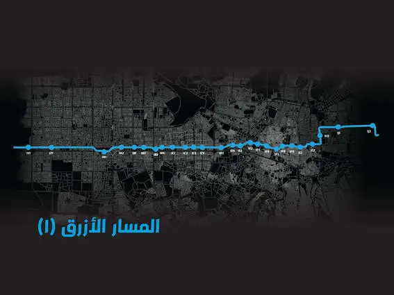
Blue Line (Line 1): Olaya to Ad Dar Al-Baida
The Blue Line Riyadh Metro routes stretches 38 kilometers from SABB to Ad Dar Al-Baida. It runs north-south along Olaya, Batha, and Al-Hayer roads. With 25 stations, it’s perfect for shoppers and workers. The line goes underground in business areas like Olaya and rises above ground in Batha. It takes about 45 minutes end-to-end.
| Key Stations: Al-Olaya Station: Connects to Red Line, near Olaya’s shops and offices. STC: Close to government buildings. Alinma Bank: Near financial hubs. National Museum: Links to Green Line, great for tourists. | Features: Serves Riyadh commercial hubs. Air-conditioned stations offer Wi-Fi. Four interchange stations make switching lines easy. Why Ride?: Visit Riyadh Zoo or shop on Olaya Street. Ideal for daily commutes or exploring. |
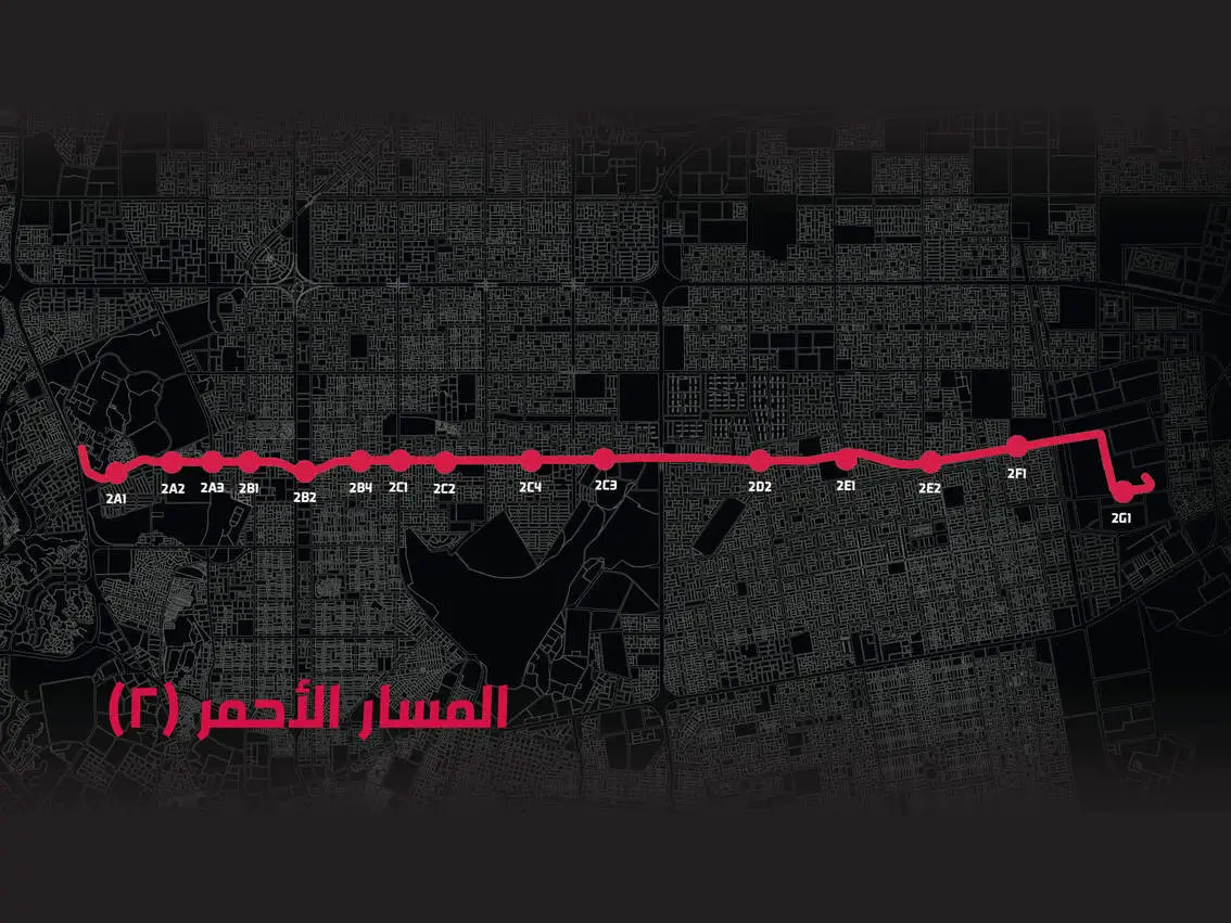
Red Line (Line 2): King Fahad Stadium to King Saud University
The Red Line Riyadh Metro routes covers 25.3 kilometers along King Abdullah Road. It connects King Fahad Stadium to King Saud University with 15 stations. Fully elevated, it’s great for sports fans and students. The trip takes about 30 minutes.
| Key Stations: King Fahad Stadium: Perfect for game days or concerts. King Saud University: Key for students and faculty. Riyadh Exhibition Centre: Near event venues. | Features: Three interchange stations link to Blue, Green, and Violet lines. Stations have parking for 200–600 cars. Why Ride?: Catch a match at King Faisal bin Fahd Stadium or study at King Saud University. Fast and fun! |
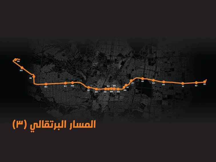
Orange Line (Line 3): Khasm El Aan to Jeddah Expressway
The Orange Line Riyadh Metro routes spans 40.7 kilometers, the longest line. It runs east-west from Khasm El Aan to Jeddah Expressway via Al-Madinah Al-Munawarah Road. Opened January 5, 2025, it has 22 stations. It mixes elevated, underground, and at-grade sections. The full route takes about 50 minutes.
| Key Stations: Jeddah Road: Near western shopping areas. An Naseem: Close to residential zones. Harun Al Rashid Road: Links to local markets. | Features: Connects western Riyadh. Two interchange stations join Blue and Violet lines. Solar-powered stations save energy. Why Ride? Shop or visit friends in western neighborhoods. Easy access to Jeddah Expressway transport. |
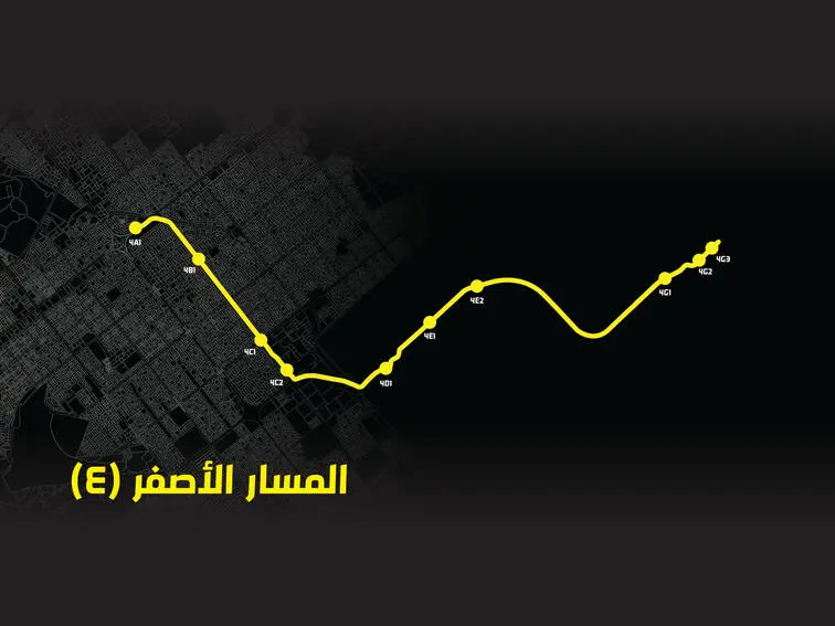
Yellow Line (Line 4): King Khalid International Airport to KAFD
The Yellow Line Riyadh Metro runs 29.6 kilometers from King Khalid International Airport to King Abdullah Financial District (KAFD). Opened December 1, 2024, it has 10 stations, mostly elevated. The trip takes about 35 minutes.
| Key Stations: KAFD Station: Links to Blue, Violet, and KAFD monorail. Designed by Zaha Hadid. Airport Terminals 1-2: Perfect for travelers. | Features: Key for business professionals and tourists. Stations offer Wi-Fi and parking. Interchange at KAFD simplifies transfers. Why Ride?: Fly in and reach KAFD’s offices fast. Great for King Khalid International Airport metro access. |
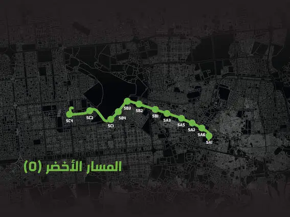
Green Line (Line 5): King Abdulaziz Road
The Green Line Riyadh Metro routes covers 12.9 kilometers along King Abdulaziz Road. Fully underground, it connects the Ministry of Education to the National Museum. Opened December 15, 2024, it has 12 stations. The ride takes about 20 minutes.
| Key Stations: National Museum: Links to Blue Line, near historic sites. Ministry of Education: Serves government workers. Ministry of Defense: Close to key offices. | Features: Ideal for Riyadh historical areas. Two interchange stations connect to Red and Blue lines. Stations have real-time displays. Why Ride?: Explore Qasr Al-Hokm or visit government offices. Perfect for history buffs and workers. |
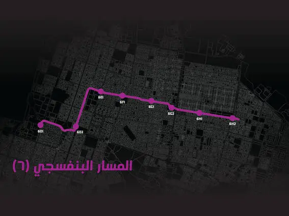
Violet Line (Line 6): Abdurrahman Bin Awf to Sheikh Hassan Bin Hussain
The Violet Line Riyadh Metro routes spans 29.7 kilometers from An Naseem to King Abdullah Financial District. It follows Abdurrahman Bin Awf and Sheikh Hassan Bin Hussain Bin Ali roads. Mostly elevated, it opened December 1, 2024, with 11 stations. The trip takes about 40 minutes.
| Key Stations: KAFD Station: Connects to Blue and Yellow lines. Imam Mohamed Bin Saud University: Great for students. An Naseem: Near residential areas. | Features: Serves Riyadh residential transport. Three interchange stations link to Orange, Red, Yellow, and Blue lines. Stations offer parking. Why Ride?: Visit friends in residential zones or study at the university. Comfortable and quick! |
| Line | Route | Length | Stations | Key Feature |
| Blue | Olaya to Ad Dar Al-Baida | 38 km | 25 | Commercial hubs |
| Red | King Fahad Stadium to King Saud University | 25.3 km | 15 | Sports and education |
| Orange | Khasm El Aan to Jeddah Expressway | 40.7 km | 22 | Western connectivity |
| Yellow | Airport to KAFD | 29.6 km | 10 | Airport access |
| Green | King Abdulaziz Road | 12.9 km | 12 | Historical areas |
| Violet | An Naseem to KAFD | 29.7 km | 11 | Residential zones |
Key Stations and Hubs of the Riyadh Metro
The Riyadh Metro’s four major hubs make travel easy and fast. Al-Olaya, KAFD, Qasr Al-Hokm, and Western stations connect multiple lines and buses. These hubs offer air-conditioned spaces, Wi-Fi, and park-and-ride facilities for 200–600 cars at 21 locations. Below, explore each hub’s unique features. Check rcrc.gov.sa for maps or download the Riyadh Metro Guide app.
Al-Olaya Station
Al-Olaya Station sits in Riyadh’s business heart. Covering 11,000 m², it links the Blue and Red Lines. Its modern design, by Gerber, serves shoppers and workers. Find restaurants, shops, and offices nearby. Park-and-ride options make driving and riding simple. Al-Olaya Station is perfect for professionals and tourists visiting Olaya Street’s malls.
KAFD Station
KAFD Station, in the King Abdullah Financial District, connects Blue, Yellow, and Violet Lines, plus the KAFD monorail. Spanning 8,150 m², Zaha Hadid’s design shines. It’s a top pick for business travelers. Wi-Fi and parking keep you connected and mobile. KAFD Station links to offices and financial hubs, saving time.
Qasr Al-Hokm Station
Qasr Al-Hokm Station, designed by Snøhetta, covers 19,600 m². It joins Blue and Orange Lines near historic sites. Tourists love its access to Qasr Al-Hokm and the National Museum. Air-conditioned with real-time displays, it’s comfy and clear. Government workers use it daily. Park-and-ride options add convenience.
Western Station
Western Station, at Al-Suwaidi’s Central Vegetable Market, spans 12,500 m². It links Blue and Orange Lines. Designed by Omrania, it includes a 1,000-car parking building. Shoppers and residents enjoy its bus connections. Wi-Fi and clear signs make navigation easy. Western Station serves western Riyadh’s busy markets.
| Station | Lines Served | Key Features | Nearby Attractions |
| Al-Olaya | Blue, Red | 11,000 m², Wi-Fi, parking | Olaya Street malls |
| KAFD | Blue, Yellow, Violet, Monorail | 8,150 m², Zaha Hadid design | Financial District |
| Qasr Al-Hokm | Blue, Orange | 19,600 m², historic access | National Museum |
| Western | Blue, Orange | 12,500 m², 1,000-car parking | Vegetable Market |
Integration with Riyadh’s Bus Network
- The Riyadh Metro routes connects perfectly with a huge bus network. This system includes 80 routes, 2,860 stops, and 842 buses. It carries 500,000 passengers daily, making travel easy for everyone. The metro and buses work together to cover all of Riyadh. Commuters and planners love this setup for its speed and reach.
- The Bus Rapid Transit (BRT) system spans 160 kilometers across three routes. Buses run every 10 minutes on dedicated lanes. Feeder buses link neighborhoods to metro stations, ensuring last-mile connectivity Riyadh. For example, Route 07 runs from Al Batha to King Saud University, stopping at King Khalid Grand Mosque. Route 08 connects Al Batha to KAFD, passing lively markets. These routes make metro-bus integration simple and fast.
- Download the Darb app for real-time bus schedules. Riyadh metro routes helps you plan trips and find stops near metro hubs like Al-Olaya or Western Station. This network saves time and cuts traffic.
Ticketing and How to Ride the Riyadh Metro
Riding the Riyadh Metro is easy and affordable. Ticket options fit any trip. Pay SAR 4 for two hours, SAR 20 for three days, or SAR 140 for 30 days. Want extra comfort? First-class tickets cost SAR 10 (two hours), SAR 50 (three days), or SAR 350 (30 days) via the Darb app. Trains offer three classes: first, family, and individual. Family cars make travel comfy for parents and kids.
Use NFC-based smart cards for quick entry. Tap your card at station gates. The Darb app handles Riyadh Metro ticketing and navigation. Download it from rcrc.gov.sa to buy tickets or check routes. Stations have ticket machines too.
How to Buy a Ticket:
- Download the Darb app or visit a station machine.
- Pick your ticket: 2-hour, 3-day, or 30-day.
- Pay with cash, card, or mobile.
- Tap your smart card or app to enter.
Why the Riyadh Metro Matters
The Riyadh Metro changes life in Saudi Arabia’s capital. It cuts traffic by 250,000 car trips daily, saving 400,000 liters of fuel. This reduces air pollution and lowers carbon emissions by 400,000 tons yearly. Residents enjoy faster commutes, with trains arriving every 3–7 minutes. The metro carried 1.9 million passengers in its first week, showing huge demand.
It aligns with Vision 2030 Saudi Arabia, boosting economic growth and eco-friendly transport Riyadh. Businesses near stations thrive as foot traffic grows. Property values rise, attracting investors. The metro connects tourist spots like Diriyah Gate, making travel easy. Its driverless trains, the world’s longest network at 176 kilometers, earn global praise.
Future plans include expansions to Khuzam and Badr, reaching more neighborhoods. “Riyadh Metro routes reshapes the capital’s image and redefines mobility,” says Ibrahim Al-Sultan, RCRC CEO. Solar-powered stations and regenerative braking save energy, supporting sustainable urban development. The metro makes Riyadh a global city, improving quality of life for all.
Tips for Navigating the Riyadh Metro
New to the Riyadh Metro? It’s easy to ride! Tourists and first-time users can explore Riyadh with confidence. Download the Riyadh Metro routes Guide app from rcrc.gov.sa for offline maps. It shows routes and stations clearly. Here’s how to make your trip smooth and fun.
- Ride Off-Peak: Residents, avoid rush hours (7–9 AM, 5–7 PM). Midday or evening rides are quieter.
- Use the Darb App: Buy tickets and check schedules fast. It’s great for planning.
- Pick Family Cars: Dedicated family cars keep kids and parents comfy. Look for signs at stations.
- Enjoy Accessibility: Metro station amenities include ramps and elevators. Everyone can ride easily.
- Stay Connected: Free Wi-Fi at stations like Al-Olaya helps you navigate.
Riyadh Metro for tourists is simple with these tips. Public transport accessibility makes every trip stress-free.
Frequently Asked Questions
How many metro lines are there in Riyadh and what are their names?
The Riyadh Metro consists of six color-coded lines: Blue, Red, Orange, Yellow, Green, and Purple. Each line serves different parts of the city, ensuring full coverage from the north to the south and from the east to the west.
What is the total length of the Riyadh Metro network?
The entire Riyadh Metro network stretches over approximately 176 kilometers, making it one of the largest metro systems in the Middle East.
How many stations does the Riyadh Metro have in total?
There are 85 stations across the six lines. These include major transfer stations where passengers can switch between routes without exiting the metro system.
Which routes or lines are currently operational?
As of 2025, the Blue and Red lines are fully operational, while the remaining lines — Orange, Yellow, Green, and Purple — are opening in stages. Once completed, the full network will connect all major areas of Riyadh.
What are the key routes for travelers and daily commuters?
The Yellow Line connects King Khalid International Airport to the King Abdullah Financial District, making it ideal for travelers. Other main routes connect important districts such as Olaya, Al Batha, and Al Malaz, helping daily commuters reach business, shopping, and residential areas efficiently.
What are the fare options and ticket types available?
Passengers can choose between Standard and First Class tickets. Available passes include a 2-hour pass, a 7-day pass, and a 30-day pass — each designed for different travel needs and budgets.
How can I plan my journey using Riyadh Metro routes?
You can plan your trip using the official metro map displayed in every station or through the Darb mobile app. Interchange stations make it easy to switch lines and reach your destination without delays.
Conclusion
The Riyadh Metro routes connects the city’s heart, from KAFD’s skyscrapers to historic Qasr Al-Hokm. Its six lines and 85 stations make travel fast and easy. Residents skip traffic, tourists visit landmarks, and planners admire its green design. Riyadh Metro routes support Vision 2030 transportation, cutting pollution and boosting the economy. Over 1.9 million riders used it in its first week, per the Royal Commission for Riyadh City.