Riyadh Metro Route
Riyadh Metro Route
Discover how the Riyadh Metro changes travel in Saudi Arabia’s capital. The Riyadh Metro, launched in December 2024, spans 176 kilometers. It’s the world’s longest driverless metro, connecting the city with 85 stations. This modern system eases traffic in Riyadh, a city expecting 8 million people by 2030. It supports Vision 2030, making travel faster and greener. The metro cuts congestion and boosts urban mobility for everyone.
What is the Riyadh Metro?
The Riyadh Metro route drives Saudi Arabia’s modern transport vision. It anchors the King Abdulaziz Project for Riyadh Public Transport. This $22.5 billion network stretches 176 kilometers across 85 stations. Driverless trains ensure safe, fast travel. Solar-powered stations save 20% of energy, promoting sustainability. The metro carries 1.16 million passengers daily now and can handle 3.6 million later. It transforms Riyadh’s urban mobility for a growing city.
- Cost: $22.5 billion
- Network: 176 km, 85 stations
- Technology: Driverless trains
- Sustainability: Solar-powered stations
- Capacity: 1.16M daily passengers, up to 3.6M
Riyadh Metro Routes
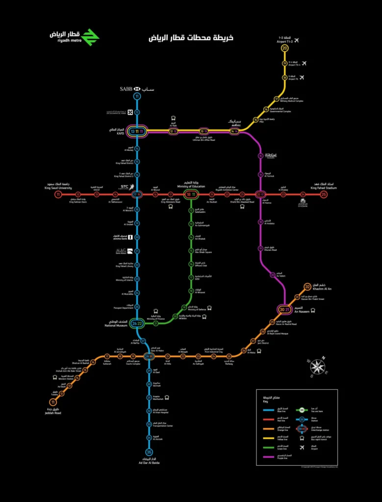
The Riyadh Metro route connects the city with six colorful lines. Each line serves unique areas and attractions. Explore the Blue, Red, Orange, Yellow, Green, and Purple Lines below. A table summarizes their routes, lengths, and key stops. Check the Riyadh Metro route map for easy planning.
Blue Line: The Heart of Riyadh
The Riyadh Metro route is a state-of-the-art rapid transit system designed to ease traffic congestion and enhance public transportation in Riyadh, Saudi Arabia. It is one of the largest metro projects in the world, featuring six lines covering 176 kilometers and 85 stations. While the project has faced delays, phased openings began in 2024, with full operation expected soon.
Red Line: East-West Connector
The Red Line travels east-west on King Abdullah Road. It covers 24.2 km with 15 stations. Key stops include King Saud University and Riyadh Exhibition Center. Two-car Siemens trains run this route. It serves students and event-goers. The line opened on December 15, 2024. It connects vibrant neighborhoods.
Orange Line: The Longest Route
The Orange Line stretches 40.7 km along Al-Madinah Al-Munawarah Road. It has 22 stations. Key stops include Western Station and Jeddah Road. This line links east and west Riyadh. It opened on January 5, 2025. Buses connect at Western Station. It’s great for commuters.
Yellow Line: Airport Access
The Yellow Line runs 29.6 km to King Khalid International Airport. It features 9 stations. Key stops include Airport T5 and PNU. It connects travelers to central Riyadh. Three underground stations serve the airport. It opened on December 1, 2024. Perfect for tourists.
Green Line: Cultural Hub
The Green Line covers 12.9 km along King Abdulaziz Road. It has 12 stations, all underground. Key stops include National Museum and Ministry of Education. It serves government and cultural sites. It opened on December 15, 2024. Ideal for history lovers.
Purple Line: Eastern Link
The Purple Line spans 30 km on Abdurrahman Bin Awf Road. It includes 11 stations. Key stops include SABIC and KAFD. It connects eastern neighborhoods to downtown. It opened on December 1, 2024. Great for business commuters.
| Line | Length | Stations | Key Stops |
| Blue | 38 km | 25 | KAFD, Qasr Al-Hokm, STC |
| Red | 24.2 km | 15 | King Saud University, Riyadh Exhibition Center |
| Orange | 40.7 km | 22 | Western Station, Jeddah Road |
| Yellow | 29.6 km | 9 | Airport T5, PNU |
| Green | 12.9 km | 12 | National Museum, Ministry of Education |
| Purple | 30 km | 11 | SABIC, KAFD |
Our Guide to Riding the Riyadh Metro
Riding the Riyadh Metro route is easy and fun. Tickets cost SAR 4 for 2 hours. A 3-day pass is SAR 20. A 30-day pass costs SAR 140. First-class tickets, available via the Darb app, start at SAR 10. Students and seniors get 50% off. Use NFC smart cards for quick access. Stations offer air-conditioning, real-time screens, shops, and parking. The metro links to 80 bus routes with 842 buses. Park-and-ride lots at 25 stations make driving simple.
How to Buy a Ticket
- Download the Darb app or visit a station kiosk.
- Choose your ticket: 2-hour, 3-day, or 30-day.
- Pay with cash, card, or mobile.
- Tap your NFC card or app to enter.
Must-Visit Stations on the Riyadh Metro
The Riyadh Metro route connects you to Saudi Arabia’s vibrant culture and bustling commerce. Visit iconic stations like KAFD, Qasr Al-Hokm, and National Museum. Each offers unique designs and easy access to landmarks. Explore Riyadh’s heritage and modern hubs by metro. Check out Top Things to Do in Riyadh for more ideas.
King Abdullah Financial District (KAFD) Station
KAFD station spans 8,150 m² and links Blue, Yellow, and Purple Lines. Its sleek design screams modern Riyadh. Step off to explore the financial district’s towers. Enjoy nearby cafes and shops.
Qasr Al-Hokm Station
Qasr Al-Hokm, designed by Snøhetta, sits on the Blue Line. Its bold look reflects Saudi tradition. Walk to Al Rajhi Grand Mosque for a spiritual visit. The nearby historic district buzzes with culture. Perfect for history fans.
National Museum Station
The Green Line’s National Museum station opens Saudi heritage to you. Its underground design keeps you cool. Visit the National Museum to see ancient artifacts. It’s a must for tourists and families.
How the Riyadh Metro is Shaping the Future
What’s Next for the Riyadh Metro?
The Riyadh Metro route plans big growth to keep the city moving. Expansions target Khuzam, Fursan Suburbs, Badr, and Shafa District. A $21 billion project with French companies will add new lines by 2030. Khuzam, near the airport, grows with 30,000 homes. Fursan Suburbs plans 50,000 homes. Station naming rights attract businesses. Retail spaces in stations boost shopping options. “We’re building a connected future,” says RCRC’s CEO. The Riyadh Metro route expansion supports Vision 2030’s vibrant city goals.
- Expansion Areas: Khuzam, Fursan Suburbs, Badr, Shafa District
- Investment: $21 billion for new lines
- Commercial Growth: Station naming rights, retail spaces
Frequently Asked Questions (FAQ) — Riyadh Metro Route
How many lines does the Riyadh Metro have?
The Riyadh Metro consists of six lines: Blue, Red, Orange, Yellow, Green, and Purple.
How many stations are there?
There are a total of 85 stations spread across all six metro lines.
What is the total length of the network?
The Riyadh Metro network covers approximately 176 kilometers.
When do trains run (operating hours)?
The metro operates daily from 6:00 AM to 12:00 AM (midnight). On Fridays, service usually starts around 8:00 AM.
What are the fares or ticket types?
There are Standard and First Class tickets.
- 2-hour pass: 4 SAR (Standard), 10 SAR (First Class)
- 7-day pass: 40 SAR (Standard), 100 SAR (First Class)
- 30-day pass: 140 SAR (Standard), 350 SAR (First Class)
How can I buy tickets?
Tickets can be purchased via the Darb app, at ticket vending machines in metro stations, or by using contactless payment methods such as smart cards or bank cards.
Conclusion
The Riyadh Metro route transforms Riyadh’s urban mobility. It connects neighborhoods, cuts traffic, and boosts a greener city. Six lines link key spots like KAFD and National Museum. Affordable tickets and the Darb app make travel easy. The metro drives Vision 2030’s sustainable future. Hop on for a smoother, faster ride. Download the Darb app to start your Riyadh Metro adventure today!