Riyadh Metro Map
Riyadh Metro Map
The Riyadh Metro transforms how people move in Saudi Arabia’s bustling capital. Launched in 2024, it’s the world’s longest driverless metro. Spanning 176 km, it connects 85 stations across six vibrant lines. Residents zip to work, tourists explore landmarks, and urban planners admire its smart design. The Riyadh Metro Map guides everyone with ease.
Overview of the Riyadh Metro
The Riyadh Metro powers Saudi Arabia’s capital with modern transit. It forms the heart of the King Abdulaziz Project for Riyadh Public Transport. This massive system stretches 176 km, linking 85 stations across six lines. It cost $22.5 billion to build. The world’s longest driverless metro, it opened in phases. Lines 1, 4, and 6 started on December 1, 2024. Lines 2 and 5 followed on December 15, 2024. Line 3 launched on January 5, 2025. It eases traffic jams and cuts pollution, aligning with Saudi Vision 2030. The metro boosts sustainability and connects key spots like airports and universities.
Understanding the Riyadh Metro Map
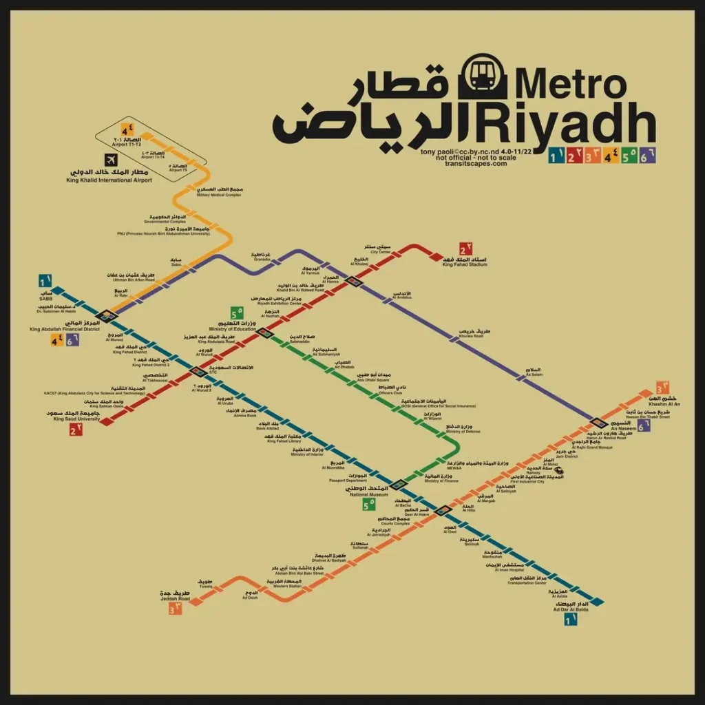
The Riyadh Metro Map guides travelers through Saudi Arabia’s capital with ease. Its design matches Riyadh’s street grid. A white background shows the city, while ochre highlights desert areas. Bilingual Arabic and English labels name all 85 stations. Icons mark landmarks like the National Museum and KAFD for quick navigation.
Six color-coded metro lines stand out clearly. Blue (Line 1) runs north-south along Olaya Street. Red (Line 2) follows King Abdullah Road. Orange (Line 3) stretches east-west, mostly elevated. Yellow (Line 4) links the airport to KAFD. Green (Line 5) connects via the National Museum. Purple (Line 6) serves areas like Granada. Download the high-resolution Riyadh Metro Map PDF from the Royal Commission for Riyadh City. This map makes exploring Riyadh simple and fun.
| Line | Color | Length | Stations | Key Stops |
| 1 | Blue | 38 km | 25 | KAFD, National Museum |
| 2 | Red | 25.1 km | 15 | King Saud University, STC |
| 3 | Orange | 41.6 km | 20 | Riyadh Rail Station |
| 4 | Yellow | 12.9 km | 9 | Airport T1-2, PNU |
| 5 | Green | 12.9 km | 12 | Ministry of Finance |
| 6 | Purple | 29.7 km | 11 | Granada, KAFD |
Exploring the Six Metro Lines
The Riyadh Metro’s six lines connect the city with vibrant routes. Each line serves unique areas and landmarks. Let’s explore them!
- Blue Line Riyadh (Line 1) runs 38 km north-south. It covers 25 stations along Olaya and Batha Streets. Key stops include SABB, KAFD, and Ad Dar Al Baida. It links downtown with bustling neighborhoods.
- Red Line Riyadh (Line 2) spans 25.1 km. It has 15 stations along King Abdullah Road. You’ll find King Saud University and STC stops here. This line serves students and professionals.
- Orange Line Riyadh (Line 3) stretches 41.6 km east-west. Its 20 stations, mostly elevated, include Khashm Al An and Riyadh Rail Station. It connects distant suburbs efficiently.
- Yellow Line Riyadh (Line 4) covers 12.9 km. With 9 stations, it links King Khalid International Airport to KAFD. Stops like Airport T1-2 and PNU make travel easy.
- Green Line Riyadh (Line 5) runs 12.9 km with 12 stations. It intersects at National Museum and includes Ministry of Finance. It’s perfect for central city trips.
- Purple Line Riyadh (Line 6) spans 29.7 km with 11 stations. Stops like An Naseem, Granada, and KAFD connect growing areas.
Key Stations and Connectivity
The Riyadh Metro map connects everyone through four major hubs. These stations make travel easy and fast.
- KAFD Station links Lines 1, 4, and 6. It connects to the KAFD monorail, serving the financial district. Business travelers love its modern vibe.
- National Museum Station joins Lines 1 and 5. Its design mimics Saudi mountains, wowing tourists. It’s a gateway to history.
- Qasr Al Hokm Station ties Lines 1 and 3. Located in a historic area, it draws visitors to cultural sites.
- STC Station connects Lines 1 and 2. Designed by Gerber Architekten, it blends style and function for commuters.
- These hubs link to landmarks like King Khalid International Airport, universities, and malls. You can hop off at Airport T1-2 or shop at Riyadh Season. The metro works with the Riyadh Bus Network, offering 2,860 stops, 80 routes, and 842 buses. This combo covers the whole city.
How to Use the Riyadh Metro Map
The Riyadh Metro Map makes city travel easy. Color-coded lines guide you to 85 stations. Blue, Red, Orange, Yellow, Green, and Purple lines stand out clearly. Landmark icons, like National Museum or KAFD, help you spot key stops. Bilingual Arabic and English labels suit everyone. Download the map from the Royal Commission for Riyadh City or Dreamin’. Buy tickets with the Darb App, available on Android and iOS. A 2-hour pass costs SAR 4. A 3-day pass is SAR 20. Grab a 7-day pass for SAR 40 or a 30-day pass for SAR 140.
Frequently Asked Questions
What does the Riyadh Metro Map show?
The Riyadh Metro Map displays all six metro lines—Blue, Red, Orange, Yellow, Green, and Purple—along with their routes, interchange stations, and key city landmarks.
How many lines are on the Riyadh Metro Map?
There are six color-coded lines connecting major areas of Riyadh, including King Khalid International Airport, King Abdullah Financial District, and downtown Riyadh.
Can I download or view the Riyadh Metro Map online?
Yes, the interactive Riyadh Metro Map is available online, allowing users to zoom in, view routes, and explore nearby attractions and stations.
Which are the major interchange stations on the map?
Important interchange stations include King Abdullah Financial District Station, STC Station, Qasr Al-Hokm Station, and Western Station, connecting multiple metro lines.
Is the Riyadh Metro Map updated regularly?
Yes, the map is updated regularly to reflect any route changes, station openings, or service updates across the network.
Sustainability and Innovation
The Riyadh Metro map leads with cutting-edge features. Driverless trains use Unattended Train Operation technology for precision. Air-conditioned stations keep commuters cool in Riyadh’s heat. Solar panels power 20% of lighting and cooling needs. This saves energy and cuts costs. Safety shines with CCTV cameras, early warning systems, and real-time control center links. The metro slashes carbon emissions by replacing car trips. It aligns with Saudi Vision 2030, boosting sustainable transport in Riyadh. The system supports a cleaner, smarter city. It connects people to jobs and landmarks with eco-friendly travel.
Future of the Riyadh Metro
The Riyadh Metro plans big growth. Expansions will reach suburbs like Khuzam, Fursan, Badr, and Shafa District. These routes connect more communities. The metro’s capacity jumps from 1.16 million to 3.6 million passengers daily by 2035. This supports Saudi Vision 2030’s push for better cities. New lines will link growing areas, easing traffic. Users on X mention last-mile connectivity issues. They want better bus links to stations. Planners aim to improve the Riyadh Bus Network with 842 buses. This fixes gaps for commuters. The metro drives a greener, connected Riyadh.